


AERIAL OPERATIONS
Drone Cell Tower Inspection, Roof Inspections, Survey & Mapping
At Private Utility Locating of Central Virginia, we provide professional drone mapping, aerial inspections, 2D and 3D modeling, and high-resolution site documentation for contractors, engineers, developers, facility managers, and project teams. Based in Lynchburg, Virginia, our advanced aerial capabilities support construction, infrastructure, utilities, commercial and industrial facilities, land development, and large-scale site investigations throughout Virginia and the Southeast.
Advanced Aerial Mapping & Inspection Capabilities
From construction sites and commercial properties to industrial facilities and large-scale infrastructure, Private Utility Locating of Central Virginia uses advanced drone technology to capture detailed aerial data, document site conditions, and inspect areas that may be difficult, costly, or unsafe to access from the ground.
-
High-resolution aerial inspections
-
2D orthomosaic mapping
-
Detailed 3D site and structure modeling
-
Construction progress monitoring and documentation
-
Roof, building, façade, and structural inspections
-
Utility corridors and infrastructure inspections
-
Pre- and post-construction site documentation
-
Stockpile and material volume measurements
-
Earthwork and site-development documentation
-
Roads, bridges, drainage systems, and other infrastructure
-
Large commercial, industrial, and undeveloped properties
-
Detailed visual inspection of difficult or elevated areas
-
Point-cloud and photogrammetric data collection
-
Site-condition and asset documentation
Our drone services can support


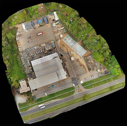


Advanced Aerial Mapping & Inspection Capabilities
-
Drone Mapping & Site Surveys
-
Aerial Inspections & Assessments
-
2D & 3D Mapping / Modeling
-
Construction Progress Monitoring
-
Roof & Building Inspections
-
Infrastructure & Utility Inspections
-
Stockpile & Volume Measurements
-
Topographic & Terrain Mapping
-
Orthomosaic Mapping & Imagery
-
Pre/Post-Construction Documentation
-
Photogrammetry & Point Clouds
-
Site & Property Documentation
Schedule an Aerial Scan Today
-
Based in Central Virginia and serving all of Virginia and parts of South Carolina, North Carolina, Maryland, and a large portion of the Southeast.
-
Mobilization rates are based on the location of your job site and its distance from where our nearest project manager is based.
-
Same-week availability in most areas
Don’t risk damage, delays, or downtime. Let Private Utility Locating of Central Virginia help you plan your next project with clarity.